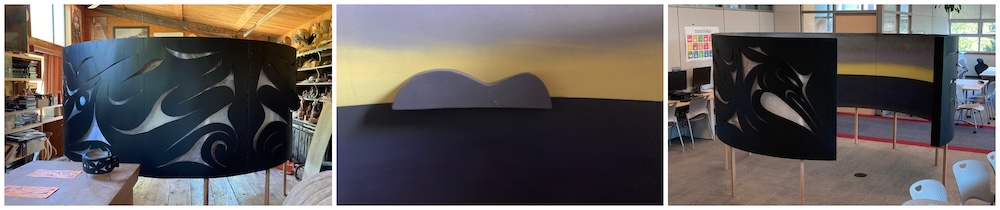
What is the Untitled ṮEṮÁĆES map?
The Untitled ṮEṮÁĆES map is the first protoype of our haptic map concept: an interactive art installation intended to teach about Indigenous and non-Indigenous place names, or toponyms.
Haptic refers to a sense of touch, but also position and motion. It is similar in approach to a tactile map, as in this example of a braille map of the lands known also as Canada. The Untitled ṮEṮÁĆES map is also a language-learning tool. It combines SENĆOŦEN and English language toponyms. A key feature of this map is that interacting with it in some way will allow you to hear place names being spoken.
The Untitled ṮEṮÁĆES map has islands that speak their name aloud in both SENĆOŦEN and English when you move them around, and it features lands in W̱SÁNEĆ Territory.
Why build a haptic map?
The haptic map has two, broad aspirations:
- to encourage us to think about how we experience connections to place through landscape and place names
- to provide new ways to learn orally about Indigenous and settler namescapes through curiosity and play
The first version of our haptic map, Untitled ṮEṮÁĆES map, is intended to represent landscape aesthetically in some way, but without the typical Western Anglo, or W̱ENITEM, cartographic marks like roads, signs, and borders. It invites you to engage physically and creatively with its artistic topography and to learn place names in unconventional ways.
Who made the Untitled ṮEṮÁĆES map?
The Untitled ṮEṮÁĆES map was built collaboratively. Kim Shortreed came up with this concept for a “haptic map” as part of his PhD project, “Contracolonial Practices in Salish Sea Namescapes.”
Kim brought the idea to TEMOSEṈ (Chazz Elliott) and they co-created the concept for the Untitled ṮEṮÁĆES map. TEMOSEṈ designed and carved the outside panels with help from Matthew Parlby-Elliott. Kim built the map’s structure (with help from TEMOSEṈ, Matt, and Ben Olsen) and the interactive islands. Jesse Campbell painted the seascape horizon.
See the Credits page to learn more about all the folks and organizations that made this project possible.
Read more about TEMOSEṈ or more about me and why I am doing this work on the About page.
Can I build my own version of a haptic map?
Yes! One goal of our haptic map project is to inspire other communities to make their own versions of artistic maps in whatever way that works for them. This site focuses on the making of the Untitled ṮEṮÁĆES map, which has its own design and construction journey, but we want to encourage others to build on what we have done to imagine something new.
See the Map Origins page for more on the inspirations that guided the map’s concepts.
Where is the Untitled ṮEṮÁĆES map, now?
The Untitled ṮEṮÁĆES map had several showings over the last three years, which you can read about on the Shows page.
The map is now a permanently housed at Bayside Middle School, in WSÁNEĆ Territory/Brentwood Bay.
TEMOSEṈ and I had always intended for the map to get young people interested in learning about WSÁNEĆ place names and territories, and we are so pleased that the map has found a good home.
What’s next?
TEMOSEṈ and I have another couple of projects in the works, both of which involve trying to find ways to build connections to communities and language through interactive art. Stay tuned!